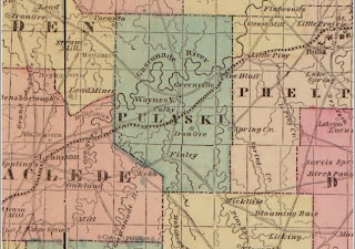
Above is an 1861 Lloyds Map. I am assuming that it is showing the projected railroad through the county as it shows the line being south of Waynesville. Keep in mind that the railroad line was originally planned to go through this part of the county before the Civil War. After the war, the line was re-platted North of Waynesville because of topography. Supposedly this new alignment followed a road that was blazed by the armies during the war. Take note of the town names of Greenville, Colby, Iron Ore, Finley, and Pine Bluff. These places are not on the map anymore.
In Mabel Manes Mottaz’s book, “Lest We Forget”, published in 1960, she states "There is still evidence of some of the fruitless tunneling and grading.". I have came across accounts that an abandoned tunnel is visible a half mile from the main gate of Fort Leonard Wood." Some portions of the work that were completed before 1861 were destroyed by Confederates during The War Between The States.
I have also read that the Irish Laborers worked intensely on the proposed line near Wildwood, or present day main gate of Fort Leonard Wood, Missouri. Legend has it, that the tunnel mentioned by Mrs. Mottaz was dug by Irish laborers. Irish Immigration was high after the Great Potato Famine of 1845-1852. Some of those who had fled disease and starvation in their homeland lived and worked in the railroad construction camps in Pulaski County before the United States Civil War. Unfortunately, cholera and smallpox, made their way through some of these railroad camps. Many succumbed, in a matter of days, and were buried in unmarked graves. It has been reported that some are buried in Dry Creek Cemetery, which is either near the Water Plant by the Gas Station on Fort Leonard Wood, or on the Fred Gray farm, East of St. Robert in Township 36, Range 11, Section 25. The latter physical description is from “Tombstone Inscriptions Throughout Pulaski County”. There is also a written report in “History of Pulaski County, Missouri Volume 1” that mentions an Irish grave site near Devil’s Elbow, Missouri although it does not give an exact location. Yet another report, by an author that I only know as Smith, refers to “the Irish Cemetery, now the gates of Fort Leonard Wood”. That same author also sheds light on this subject with these sentences: “Also by that time Irish and German laborers were working on the railroad bed and digging a tunnel in what is now known as Tunnel Hollow near the north gate of Fort Leonard Wood. Legend has it that many Irish laborers died from disease and were buried in a mass grave near the post gate along modern Route 17.”

Another side note, a railroad spur from Crocker to Waynesville was proposed during the early 1900's. Some grading was finished before the financing for the deal fell apart. The abandoned railroad bed from this effort was later rehabilitated and converted into New Highway 17, bypassing the Old Waynesville Crocker Road, and Skaggs bridge, by approximately 2 miles west.
The three books that I reference in this article are available at the 1903 Pulaski County Missouri Courthouse Museum.


